
Gold in Maryland
Source: Gold in Maryland by Karen R. Kuff, Maryland Geological Survey, 1987
http://www.mgs.md.gov/geology/minerals_energy_resources/gold.html
by Karen R. Kuff, 1987
The Maryland Journal reported in May, 1901 that "Many persons will be surprised to know that within easy walking distance of the National Capital there are no less than a half-dozen gold mines in actual operation. Prospecting is now a rather extensive industry along the banks of the Potomac, from a point near Georgetown up the river, past Great Falls, a distance of perhaps ten miles." Although no mining is currently underway in Maryland, individuals still seek their fortunes in gold.
Gold is found in rocks of the Piedmont Plateau, a belt of metamorphic rocks extending from New York to South Carolina. The metal occurs as grains, wires or sheets in quartz veins and along mineralized fault zones in the surrounding metamorphic rocks. The distribution of gold in the quartz veins is sporadic and the concentration ranges from 0.1 to 5 ppm (Reed and Reed, 1969). Sulfides sometimes found with the gold are pyrite, sphalerite, and galena. In the copper districts of Maryland, gold has often been noted as a minor accessory mineral.
The accompanying maps show old gold mines, prospects and reported gold occurrences in Maryland. The passage of time has changed the face of many of the old mines and prospects to the point where many are now overgrown or have been built on. Therefore, some locations are approximate. Names of mines or properties may also have changed. Included on both this map and the inset map are sites where gold has only been reported, not necessarily produced.
Although gold was first reported in 1849 on Samuel Ellicott's farm near Brookville, Montgomery County, no production was recorded. There are numerous versions of the first discovery of gold in the Potomac area. In 1861 during the Civil War, a Private McCleary (or McCarey) of the 71st Pennsylvania Regiment (or "1st California Volunteers") was stationed outside of Washington, D.C. While encamped in the vicinity of Great Falls, he discovered gold. It is reported that the gold was found while washing skillets in a stream near McCleary's hilltop camp overlooking the old Anglers Club. By 1867 the first shaft was sunk near the site of the Maryland Mine.
==================
GOLD, AND OTHER MINERALS OF
ROCK RUN, MONTGOMERY COUNTY, MARYLAND
From Mineral News, Vol. 16, No. 3, March, 2000. Reprinted with permission of the author and the publisher. This article may be reprinted or copied as desired for other mineral publications.
Rock Run is a small stream in southern Montgomery County, Maryland, that originates just north of Potomac Village and flows about 9.1 kilometers (about 5.5 miles) in a generally southeasterly direction to the Potomac River at the Naval Surface Warfare Center (the old David Taylor Model Basin) in Carderock. The major country rock in the area of the Rock Run watershed is interlayered mica schist and metamorphosed graywacke. It is a thick sequence of metasedimentary rock, probably of lower Paleozoic or Precambrian origin, that is exposed in extensive areas of the Piedmont, including stretches of Virginia, Maryland and Pennsylvania.
Most of Rock Run and its 3 small tributaries flow through private property, although just over 4 kilometers flows through County-owned parkland called Rock Run Stream Valley Park. It is in a serene and pristine-looking forest valley having generally steep hillsides, large old trees, lovely wildflowers (including wild orchids) and vines, and a wonderful population of deer, fox, squirrel, chipmunks, pileated woodpeckers and many other birds, turtles, snakes, fish and crayfish and a host of aquatic insects. As with most of the other 55 Montgomery County stream locations in which I have panned for microminerals and gold, Rock Run's deep sediments (the alluvium) contain a considerable amount of the heavier minerals, which together are called "black sands". They are so named because of the very dark color which is imparted by the predominance of iron-rich minerals (mostly magnetite and hematite). These "black sands" usually are of a specific gravity of about 3.0 (3 or more times the weight of an equal volume of water) or more. These heavy minerals include, in order of their specific gravity: chlorite (3.0), actinolite (3.0), limonite (3.0-4.3), micas - several species (about 3.1), tourmaline, (variety schorl) (3.1), epidote (3.4), diopside (3.4), kyanite (3.6), staurolite (3.7), garnet, several populations probably of almandine and spessartine (about 4.0), rutile (4.2), zircon (4.7), ilmanite (4.7), pyrite (5.0), hematite (5.1), magnetite (5.2), monazite (5.5), galena (7.5), gold (19), and a few others that I have not yet identified. There is also some liquid mercury (13.6), which is extremely rare, left over in the deepest sediments, from early gold recovery processes. Most everything else in the stream alluvium is lighter than a specific gravity of 3.0, and so easily washes out of a gold pan in the panning process, leaving the black sand and gold, if any, which is the heaviest mineral in the stream. Most of the suburban streams also contain the debris of modern society - broken glass, and many other kinds of durable waste such as metal, rubber, plastic, string, etc. In additon to this man made debris, I have found several other interesting things. In the deeper stream sediments, lead shot, airgun pellets and even bullets are found - probably from about two to three hundred years of hunting in the area. Some are relatively fresh, but most are much older and are frequently coated with whitish lead oxidation products (anglesite and cerussite). Another interesting things to be found are numerous, but very tiny, clear glass spheres (much smaller than 1 millimeter, (1/25th of an inch), found in parts of streams that are near paved roads. These originate in the white and yellow traffic lines painted on the roads. After this paint is freshly applied to the road, billions of these spheres are sprayed onto the surface of the paint, where they adhere and then reflect cars' headlights at night, thus illuminating the lines for drivers. Rain and traffic abrasion causes many of these spheres to wash into the streams where they settle down among the natural sands. Other stream localities may have some differences in mineralization, but there is one truism: if you don't find any black sand, you will not find any gold. However, finding black sand is no guarantee that gold is present, either. But we do know that gold is present in Rock Run and many other streams of southern Montgomery County.
GOLD DISCOVERED IN MARYLAND.
Gold was discovered in southern Montgomery County during the Civil War and the first of many mines and prospects began operating in 1867. The first mine, and the most successful, was the Maryland Mine whose remains are preserved today near the intersection of Falls Road and Mac Arthur Boulevard.
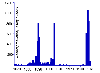
Gold production was very small and sporadic during the 73 years that mining was carried out here. Only 5,000 ounces of gold are recorded by the U. S. Mint as having come from Maryland (Montgomery County) in that time. (Knowledgeable estimates place the actual amount of gold recovered at about ten times that or more).
There were 5 gold mines along Rock Run, including a placer mining operation using water under high pressure to wash the stream and flood plain sediments through long California-style sluice boxes. The placer operation, carried out from perhaps 1910 to 1914, reportedly recovered a considerable amount of gold, including many fine nuggets, some up to four ounces. For me, the panning activity has served several beneficial purposes. It gets me out into the seclusion and peace of the wooded stream setting. By going 3 to 4 times a month year 'round, I enjoy good exercise and it seems to strengthen my back muscles. It feeds my intense interest in micromineralogy with the minerals I recover from the black sands. It has earned me about 25 cents worth of gold per hour for my efforts, but best of all has been the fact that I have found enough gold to have my wife Leona's and my rings made for our 1994 wedding. Since September 1991 when I commenced this fascinating hobby, I have panned fifty-five stream locations in Montgomery County, and have found gold in twenty-five of them. During that time I have learned a number of things about finding gold in this area:
1. Most of the richest gold mines were in a few gold-bearing quartz veins that had a higher concentration of gold than most of the others in the area.
2. All of the gold-bearing veins run roughly parallel with the general direction of the Appalachian Mountains, which trend a little east of north in this area. Some veins vary in their strike (direction) by as much as 25 to 30 degrees to the east or to the west of north.
3. Nearly all streams and smaller tributaries have been explored in the past by miners who were quite thorough in their recovery methods, so most stream sediments have been pretty well cleaned of gold.
4. Therefore, I have learned to use a compass to determine the approximate strike of a stream's bedrock, which, in this area, is generally a nearly vertical quartz/mica schist. Then I search for exposures of the bedrock or dig deep enough in the stream's alluvium to reach the upper levels of the bedrock. Most of the upper levels of the bedrock encountered in this fashion are either chemically altered to a soft consistency (saprolite - disintegrated rock that lies in its original place), or nearly so and can be removed and broken up in the gold pan. By exploiting the altered areas of the bedrock, I increase the chances of finding gold. Most of what I find in this fashion is lode gold (freshly broken out of the rock it formed in) rather than placer gold (naturally eroded out of its host rock and then stream worn). Needless to say, finding the gold in the pan is exciting since the finder is the first person to see it since it was first formed here about 200 million years ago through the actions of tremendous tectonic forces.
FINDING CUBIC GARNET
On each outing, I save most of my black sand to bring home and examine under my stereo microscope using magnifications of from 5X to 50X. This is the source of my real excitement and wonder. By examining my heavy mineral concentrates in this fashion, commencing in late 1991, I began to find occasional strange, cubic crystals that looked like garnet except for the shape. Garnet typically forms in 12 or 24 sided crystals called dodecahedrons and trapezohedrons respectively. But these cubes, which were extremely small at 1 millimeter or less, (one twenty-fifth of an inch or less) were very perplexing and none of my micromineralogist friends could explain them. By 1995, I had found perhaps fifty of these cubes. I gave two of these cubic crystals to a noted mineralogical consultant, Vandall King, who passed them to the late Eugene Foord, a renowned geologist and mineralogist at the U. S. Geological Survey, in Denver, Colorado for examination. His results were announced in a scientific paper he and King presented at the 23rd Rochester Mineralogical Symposium in April of 1996. They were in fact true cubic crystals of ferroan (iron-rich) spessartine garnet and were "probably the first cubic garnets found in the United States!". So Rock Run can now be known not only as the best gold panning stream in Maryland but also as the locality where the first U. S. cubic garnets were found.
Last revised March 2000.